

China holidays |
Search Site
|
 Book China Tours020 7487 2999sales@chinaholidays.co.uk |
Top Tourist Attractions in China

Yixi
 "For thousands of years China has been the mysterious Middle Kingdom, the fabled land between heaven and earth, steeped in legends enthralling travellers and explorers who undertook the most gruelling journeys to discover for themselves this exotic kingdom"
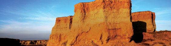
Yumen Pass (Jade Gate Pass)
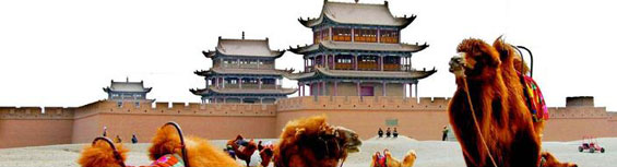
The Jade Gate Pass, situated 75 km northwest of Dunhuang, was a strategic pass on the ancient Silk Road. It was the ancient equivalent of the last gas station in the Han Dynasty before a long stretch of road. It was named because of the jade that was transported through this pass to central China. Little Square City is another name for this city which comes from a rare square piece of jade that was sent from the west to the Han emperor in the east.Today, there are two yellow clay gates at the western and northern sides of the pass. Unfortunately, some parts of the walls have collapsed due to erosion, forming huge holes.
In his poem “Go North of the Great Wall”, the Tang Dynasty poet Wang Zhihuan wrote the famous line, “Beyond the Yumen Pass the breath of spring has never crossed". Mentioning Yumen in the poem has made the pass all the more desirable and exotic as a destination.
Further north of Dunhuang, in the Gobi desert, is a section of the Han dynasty Great Wall that originally stretched for 150km. In one beacon tower, which were used as signaling stations, Han dynasty writings on bamboo, thought to be letters, official documents and the ancient equivalent of wanted posters were found amongst the ashes.
Mirages can also be seen on extremely hot days when out in the desert, just be sure not to be lured away by them, the admission price may be quite costly.
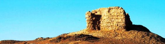
Yangguan Pass
Yangguan Pass was originally built by the Emperor Wu during the Han Dynasty and was one of the two most important passes (the other is Yumen Pass) that served to protect Dunhuang from invasion from the west. Yangguan Pass means “Southern Pass” in Chinese, and is 75 kilometres southwest of Dunhuang.During its heyday, this pass’s system of beacon towers and walls marked the western border of the Chinese Empire, although it seems slightly difficult to imagine this today since unfortunately great sections of Yangguan have been buried in the desert’s shifting sands. There are now hardly any walls in sight, and the only visible sections are the wall’s foundations. There are some ruins near the wall, the last evidence of a lost era.
The famed poet of Tang Dynasty, Wangwei, has made the site immortal. When he set off with one of his best friends, Wang wrote: “In Weicheng, the central town, it rains lightly in the morning. All the houses and the willows look fresh after the rain. I suggest you have another cup of wine, because as soon as you leave Yangguan Pass, there are no friends."
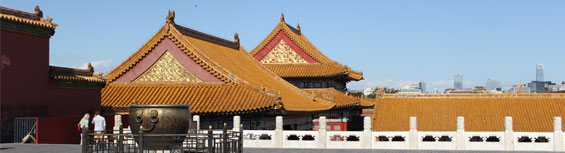
Forbidden City
The abode of 24 Ming and Qing emperors of the Celestial Empire, the Forbidden City is a fittingly awe-inspiring sight. Enclosed behind its moat and 9.9m-high walls are 980 buildings, vast courtyards and long corridors that occupy a total area of 720,000 square meters. It's alleged that as many as1,000,000 workers and 100,000 artisans participated in the construction of this imperial palace, which began in 1406 and was completed in 1420 during the reign of Ming dynasty emperor Yongle. Destroyed by fires and other calamities, many of the buildings were rebuilt and expanded during the Qing dynasty. The last emperor, Puyi, left the Forbidden City in 1924, 11 years after his abdication and the establishment of the Republic of China. After Puyi's departure, the Forbidden City, which had long been off-limits to most mortals, was opened to the public, hence its current Chinese name, gugong bowuguan, meaning "The Palace Museum."Besides its massive scale and historical significance, the Forbidden City strikes the imagination by its design. Its clear lines, perfect proportions, and dramatic color scheme of vermilion walls, white marble terraces and staircases and brilliant yellow-tiled roofs - create one of the world's most beautiful architectural complexes. It was built along a meridian line, from the Dragon's throne, an axis can be drawn directly south through the many gates, right through toQianmen and on. From his northern seat, the emperor could symbolically survey his entire kingdom. Taking all this in requires time, at least 3 hours, and a comfortable pair of shoes. The English audio tour is highly insightful and features the suave voice of Roger Moore of James Bondfame. Readers interested in the Forbidden City's past grandeur should watch by Bernardo Bertolucci, a film that was largely shot on location.
The main entry point for the Forbidden City is the Meridian Gate which is a ten-minute walk due north from Tian'anmen Square, don't confuse Meridian Gate with the the Gate of Heavenly Peace, above which hangs Mao's portrait. The "Son of Heaven," as the emperor was called, would come to the Meridian Gate to review armies and announce the new calendar. As you walk through Meridian Gate, know that in imperial times you would have been guilty of a capital offense as only the emperor could use this central archway. Officials and royal family members had to employ the side passageways.
Emerging from the Meridian Gate is a courtyard bisected by a canal in the shape of a bow that's spanned by five marble bridges. On the far side of the canal is the Gate of Supreme Harmony, which opens up to a second gigantic courtyard that held audiences of 100,000. On the north end of that courtyard is the first of three great ceremonial halls, the Hall of Supreme Harmony. This is where the Emperor read important edicts, celebrated his birthday and appointed military leaders. Inside the hall is an elaborately decorated throne flanked by cloisonne cranes (symbolizing longevity) and gorgeous columns carved with dragons.
The second ceremonial hall, called the Hall of Middle Harmony, was used by the emperor and his ministers as a staging area to prepare for official ceremonies. Directly behind it is the Hall of Preserving Harmony Where Qing dynasty New Year's Eve banquets were held. This edifice was also used as an imperial examination hall for top scholars seeking official positions.
After passing the Hall of Preserving Harmony, some visitors pause over a cappuccino at the Forbidden City's Starbucks while others meander eastward in an area that served as the quarters for imperial attendants, including, at one point, an estimated 70,000 eunuchs. There are signs pointing towards the Hall of Clocks and Hall of Jewelry where antiques are exhibited. Due north the Hall of Preserving Harmony is the Inner Palace, a series of elegant buildings and courtyards where the emperor lived with his family and concubines. In addition to a throne room and nuptial chamber, the buildings include libraries, temples and a theater. At the northern end of the compound is the delightful Imperial Garden with gnarled cypresses, scholars' rocks and pavilions. Reflecting their separate purposes, the Garden and the Inner Palace were built on a far more human scale than the grandiose ceremonial halls: the former were designed for the emperor's private life, the latter for his public persona as the embodiment of the state and Son of Heaven. The garden is also the only place in the palace grounds that has trees because of the importance of symbolism to the emperor. The palace grounds is in the shape of a square, think of it as a box. If the box has the Chinese character for tree inside, it becomes the character meaning imprisoned, not exactly an auspicious symbol for the emperor.
To the north of the garden is the exit via the north gate. Be sure to take in the spectacular view of the Forbidden City's moat, outer wall and corner guard towers. If you want an even better view, cross Jingshan Qian Jie and climb to the top of Coal Hill.
Terracotta Army (Warriors and Horses)
In 221BC, for the first time in its history, China was united under one emperor, Qin Shihuang of the Qin Dynasty (221 BC - 206 BC). The Qin emperor's influence far outlived his short dynasty. His most important achievement was unifying the various warring kingdoms and integrating writing, money, weights and measures into one centralized and standardized bureaucracy. Like many autocrats, Qin Shihuang had an early start on his own mausoleum; construction began when he was only 14 and continued for 36 years.The emperor's tomb complex is a massive memorial to a man that history remembers as both brilliant and brutal. Many parts of his rich tomb remain unexplored because current archeological technology isn't advanced enough to preserve the priceless artifacts held within.
The tomb of the Qin emperor, at 56.25 square kilometers, is best described as an underground palace with stables and an inner and outer city. Han dynasty historian Sima Qian detailed the construction effort, he wrote of the vast effort required to build the emperor's final resting place. Over 700,000 conscript and slave laborers built the tomb to hold the numerous treasures within, rivers of mercury, constellations of pearls and gems embedded into the ceiling, plus an assortment of valuables the emperor would require in his afterlife, including live soldiers, concubines and servants - plus the artisans who worked on the mausoleum lest they reveal its secrets.
Today Qin Shihuang's unopened vault, 1.5km from the Terracotta Warriors and Horses and 30 km from Xi'an, still guards its secrets. The non-descript grassy tumulus is surrounded by trees. On peaceful sunny days, the wind blows yellow earth across the countryside, what may lie underneath belies the humble surroundings and tantalizes the imagination.
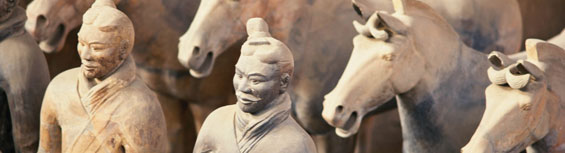
The Terracotta Warriors and Horses is only a part of the Qin emperor's tomb complex. They may have remained forgotten had it not been for the fortuitous discovery by local peasants drilling a well in 1974. What they found would excite the archeology world.
In a vault of approximately 12,000 square meters and 5 meters underground lay some 8,000 terracotta infantry soldiers, archers, cavalrymen and chariots arranged in battle formation, ready to defend their emperor's immortal soul. Each soldier is approximately 1.8m-tall, with higher-ranking soldiers being taller, and made of 7.6 cm thick terracotta clay. Each part of the hollow body was made separately, while the trunk, limbs and hands were mass-produced, the heads were individually constructed and the face of each warrior is distinct. It has been theorized the faces were sculpted from the likeness of the soldiers and artisans. The terracotta sculptures show a high level of artistry with individualized facial expressions, hairstyles and clothing and were once brightly painted with black armor, colorful red scarves and green pants, though the colors have long faded. As warriors, they each held weapon, bronze swords, spears, axes and halberds - which were still sharp when discovered, and longbows and crossbows.
Three pits containing warriors are open, a nearby fourth pit was found empty. The pits are still being excavated and in many; warriors lay toppled as if they fell in combat. Shattered and headless statues give the eerie sense of viewing the carnage of an ancient battlefield. Though a daunting task, archeologists continue to piece together the broken remains of those warriors who lost their battle against time.
Pit1 is the largest and contains about 6,000 warriors with war chariots and horses. Housed in a gigantic building that resembles an airplane hangar, the warriors are protected from the elements and tourists who view them from elevated walkways. The warriors are lined in 38 trenches, facing eastwards to the emperor's tomb.
The warriors in Pit 2 are mostly hidden and excavation continues with most of the area closed off. This pit show signs of fire damage, the wooden roof structure was burned when the mausoleum was looted by Xiang Yu, one of the warlords who battled for supremacy after the fall of the Qin dynasty. While the first pit contains mostly foot soldiers, the second pit is the mobile arm of the army with chariots, cavalryand archers. A tall statue, thought to be a general, was also found in this pit.
The third pit is the command center for the ghostly army, with 68 statues of officers around a war chariot. The clothing of the officers differ from common soldiers, the officers wear fine robes and are much taller.
There's a display hall with two bronze chariots unearthed near the base of the emperor's tomb. These elaborate half-sized chariots are intricately detailed with detailed drivers and horses that have decorated plumes and gold and silver inlaid harnesses. These richly decorated chariots feature working parts such as windows that open and close and turning handles. There are also exhibitions featuring artifacts from the pits, allowing a closer look at the intricate workmanship.
Outside the gates of the Terracotta Warriors and Horses, present day market warriors will give a shrill battle cry as you approach. They're armed with different wares, from ubiquitous replica terracotta warriors to postcards – the best defense is a good offense and that means bargaining.
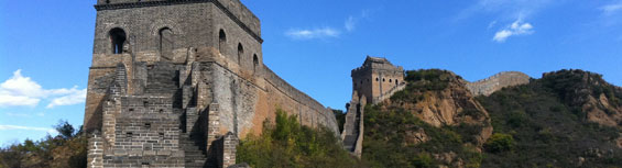
Great Wall of China
The Great Wall snakes its way across northern China, from the Yellow Sea and past the Gobi Desert for some 6,000 km. While it's not visible from the moon as has been claimed, it's still a remarkable piece of engineering and is the most famous symbol of China. The genesis of the Great Wall dates to the Warring States period from 475 to 221 BC, when Chinese feudal kingdoms built earthen ramparts to defend against nomadic invaders. It was under the fierce emperor Qin Shihuang, who unified China in 221 BC that the Great Wall really began to take shape. He conscripted some 300,000 laborers to work for ten years on joining the various pre-existing sections into a single fortified wall. The suffering of the workers who toiled in freezing winters ands corching summers became legendary. As dynasty came into being and passed into history, the Great Wall was continuously repaired and extended.The sections of the Great Wall near Beijing were renovated during the Ming dynasty, whose leaders spent a century strengthening and extending the Wall to the Yellow Sea. The previous ramparts, which were made of stones, packed earth and wood, were covered by Ming builders with bricks. They built crenellations to protect archers, widened the Wall so it could accommodate five horses abreast, and added many watchtowers. A system of beacons lit from tower to tower ensured that enemy troop movements were swiftly relayed to headquarters.
Despite such defensive features, the Great Wall failed in its purpose of keeping out invaders. It was breached several times, notably by the armies of Genghis Khan in 1215 and by Manchu troops in 1644. Conversely, the Great Wall was a tremendous success in forging a sense of nationhood since it marked the physical boundary between China and abroad, and the psychological boundary between civilization and chaos. Scaling forbidding landscapes of mountains and deserts, the Great Wall was also a triumph of the emperor's will over nature.
There are three major sections of the Great Wall open to tourists near Beijing: Badaling, Mutianyu and Simatai. All three are built on steep terrain so it's a good idea to wear comfortable shoes and bring water. This advice holds especially true when going to the Simatai section or to the "Wild Wall" sections that haven't been restored. Many ex-pats enjoy hiking along the"Wild Wall" but it's not for the faint of heart: climbing conditions can be arduous and there are no signposts, so hikers will need a good map or a guide.
Whatever section you choose to visit, the simplest way to get there is to hire a car and driver for the day. Another option is to join a guided tour, these cost around 500 to 700 Chinese Yuan per person. Both private cars and tour bus reservations can be booked through hotels and travel agencies.
Badaling Section
Only 70km away by superhighway, Badaling is the closest section of the Great Wall to Beijing and can be visited in half a day. Moreover, its proximity to the Ming Tombs means both sites can be seen in a single outing. Badaling was completely restored after 1957. It has a chairlift and fast food restaurants and can be very crowded with hawkers and tourists, but all that fades away once you leave the parking area and begin to walk along the Wall.
Mutianyu Section
Mutianyu is located some 90km north of Beijing, and like Badaling, is a recently renovated section that's very popular. Mutianyu lies in rugged territory and reaching the Wall from the main gate involves a strenuous climb up a steep stairway, but fortunately there's a chairlift. Once on top, the views of the Wall undulating down wooded canyons and up mountain ridges are breathtaking.
Simatai Section
The Simatai section is a dramatic testimony to Ming engineering skills with one section as steep as 85 degrees. Only partially restored, Simatai allows athletic visitors who climb past the first watchtowers to see the Wall in its wild, crumbling state. Less intrepid visitors can take a gondola. Simatai is 110km northwest of Beijing.
Silk Road
Silk was first cultivated in China around 2600 BC, but it would take two and a half millennia for it to spread west. The Romans first encountered the material while battling the Parthians in 53 BC and were told it came from a mysterious tribe in the east. Roman agents were dispatched, commodities bartered and the “Silk Road” established.The Chinese had known about trade routes going west across the Taklamakan Desert for centuries, however these routes only became important when Emperor Wudi of the Han dynasty formed alliances with western tribes against the northern nomads, China’s old enemy.
In 138 BC, Zhang Qian, a court official, was sent west to negotiate with the Yuezhi tribe. Unfortunately, he was captured and imprisoned for over ten years by the northern nomads. When he eventually escaped, he discovered the Yuezhi had resettled in northern India and had adopted a nonviolent way of life. Zhang Qian compensated for his diplomatic failure by returning with invaluable information about the areas to the west of the empire and the intrigued emperor launched more exploratory missions.
Trade quickly grew from these diplomatic missions and the Silk Road was established. It would eventually become a vast conduit for exchanging goods and information, stretching between three continents and thousands of kilometers from Chang’an (the Han dynasty capital) to Dunhuang, through Turpan, Kashgar and into modern Afghanistan, Iran and Syria with further branches connecting to the Roman Empire and the Black Sea. Most caravans only traveled a fraction of the route; goods passed through a chain of middlemen from China through Central Asia to Europe.
However, more important than the exchanging of goods was the exchanging of ideas. Buddhism came to China from India over the Karakorum pass and was spread by Silk Road merchants. The Eastern Han emperor showed signs of interest in this new faith, but it was during the Northern Wei dynasty when the government adopted it as the state religion. Many of the local ethnic groups living along the Silk Road adopted Buddhism and the particularly devout carved grand monuments along the route.
It was during the Tang dynasty when the Silk Road reached its apex; the monk Xuan Zang made his epic journey to India in search of Buddhist scriptures; Chang’an, the cosmopolitan capital, had over 5,000 foreign traders and each year tons of silk and spices passed through the city gates. However, when the Tang dynasty fell, so did trade. The Silk Road finally passed out of use in the 10th century with the discovery of faster and more convenient sea routes.
The 19th century saw a revived interest in the ancient Silk Road and it was at this time when the name was first coined. Treasure hunters and archeologists stormed the Silk Road, taking with them whatever treasures they could carry. These relics now fill museums across the world while countless treasures still lie buried in the sand, maintaining the mystique and romance of the Silk Road.
Banqo Village Remains
Banpo Village, inhabited long before the glories of the various empires that made Xi'an home, was discovered in 1953. The village is the earliest example of the Neolithic Yangshao culture that's renowned for its colorful ceramics. These ceramics feature etchings that are possibly an early form of writing. The 6,000-year-old site east of Xi'an dates back to 4500 BC. The site itself is made up of 45 houses and buildings, 250 adult graves, 73 children's burial urns, six pottery kilns divided into three separate residential, grave and manufacturing areas. The villagers cultivated various crops, domesticated pigs and dogs, fished in the nearby WeiRiver and manufactured ceramics.Some archeologists have argued that Banpo represents a matriarchal society, though the supporting evidence remains vague. The site has been a treasure trove of artifacts though, with over 8,000 pieces unearthed with some of the most interesting artifacts are the children's burial urns. Children weren't buried with the adults, but placed in burial urns which were buried close to homes. The lids on the urns have a hole in the top in order for the spirits of the deceased to travel to the afterworld.
The Banpo site is made of two parts, the Neolithic Village and theme park-esque Matriarchal Village.
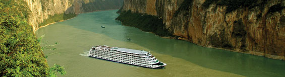
Three Gorges
The most celebrated of natural wonders in China, the Three Gorges include the Qutang Gorge (8 kilometers/5 miles), the Wu Gorge (46 kilometers/29 miles), and the Xiling Gorge (66 kilometers/41 miles). This region of towering slopes, swirling waters, and quaint villages is the quintessential image of China.Qutang Gorge
Smallest and narrowest of the gorges, the Qutang is renowned for its tortuous waters and towering cliffs. The “Kui Men” gate – two cliffs that mark its entrance – is an image known throughout China.
Wu Gorge
The magical Wu Gorgeis highlighted by the majestic peaks mantled in verdant forests. Legend has it that Yao Ji, a celestial being, loved this area so much that she and her 12 attendants were transformed in the peaks, which grace the landscape of the gorge. The Shennong Stream runs into the Yangtze at the Wu Gorge.
Xiling Gorge
The longest of the gorges, the Xiling is celebrated for the many smaller gorges that mark its course. Historically, this was the most perilous part of any journey through the gorges, as boulders menaced ships making the trip up and down river. Today, the boulders are gone but the gorge is famous for the mighty Three Gorges Dam that lies near its entrance.
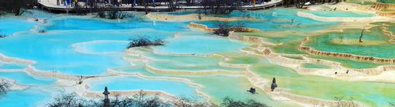
Huanglong
Twinned with Yellowstone National Park in the USA and praised for its colorful limestone ponds, Huanglong, which means Yellow Dragon Mountain, lies in the south part of Min Shan in Songpan County. Situated in the northwest of Sichuan Province and 128km south of Jiuzhaigou, the Huanglong Valley is edged by snow-capped peaks and glaciers. An incredible bio-diversity of flora and fauna thrives here alongside spectacular limestone formations, waterfalls and hot springs. The area also has a population of endangered animals, including the giant panda and the Sichuan golden snub-nosed monkey.Making it onto the UNESCO World Heritage Site listings in 1992, Huanglong is sectored into two gorges, Huanglong and Muni. The Huanglong part of the park is watered by tributaries of the Fujiang River, which run down Snow Mountain Ridge, feeding hundreds of small lakes and ponds. The rocks on the valley's sides have been twisted into weird shapes by snow and rain but so too the rocks lying beneath the clear lake water. Most visitors first concentrate on the Huanglong section of the park. Dotted with ponds and patterned like a dragon, Huanglong Valley cuts its way through Min Shan.
More than half of the Huanglong zone is forested, with mountain pines mixing with broadleaf trees, flowers, shrubbery and meadow grasslands. Sitting atop the parkland, Snow Mountain Peak is permanently snow-covered and looks a daunting climb. Equally daunting are the spectacular cliffs overhanging the Fujiang River's drive through the Danyun Gorge. Algae and growth in the little lakes below turn the water a rainbow of colors: orange, yellow, green and blue. Other karst features include long limestone shoals, fan-shaped slopes of limestone deposited and covered by a thin layer of flowing water.
The Muni Gully subdivision consists of two parallel small gullies, Zhaga and Erdaohai. The hot springs in Pearl Boiling Lake simmers at 21°C in what amounts to a massively sized swimming pool. The waters of both springs have high mineral contents and are said to have important medicinal properties. Muni Gully also contains a number of very attractive lakes and the Zhaga Waterfall.
Because of its relatively pristine state, the forests at Huanglong are home to hundreds of bird species. On a walk into the higher reaches of the hills, away from the hordes of tourists below, one hears a cacophony of different birdcalls. Pandas meanwhile are found at four to five specific locations within the site, though visitors should tread carefully and slowly if they're hoping to catch a glimpse. Much harder to spot is Sichuan golden snub-nosed monkey, an endangered species that hides out in Huanglong's more undisturbed woodlands.
As in Jiuzhaigou, but perhaps a more low key presence, there are also plenty of indicators of Tibetan religion, culture and folklore in Huanglong. A pair of small stone pagodas stands near the entrance to the park that date from the Ming dynasty. Nearby the Huanglong Temple and the ruins of a much older temple still draw plenty of worshippers. Also in the vicinity, Body Washing Waterfall is said to have healing properties for those who bathe in its waters.
Huanglong Town is a medium sized Tibetan village close to the center of the main Huanglong subdivision. Local Tibetan herdsmen grazing their livestock and cultivating the land nearby make for great subjects if you're slinging a camera. The larger town of Songpan cuts Huanglong off from the Muni gully subdivision and is worth exploring in its own right if only for its stout town walls, Tibetan architecture and colorful vitality. It's also a good spot for souvenir hunting.
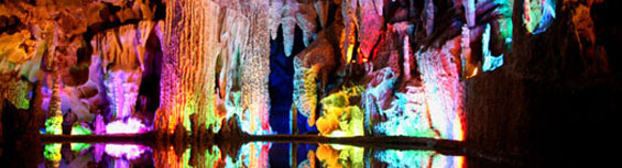
Reed Flute Cave
The Reed Flute Cave is situated on Guangming Hill, a small hill around 4 kilometers to the northwest of downtown Guilin. It is so called for the fact that a large area of reeds had been grown in this region since ancient times and the reeds had been used for making flutes and pipes.The cave is about 240 meters deep and visitors will walk for a hour through a zigzagging sea of stalactites and stalagmites. In the multi-color artificial lights, the various rock formations inside form a magic effect. People call this cave a Natural Arts Palace.
The cave is also well-known for its over 70 wall inscriptions from the Tang Period which bear eloquent witness to the cave's long history.

Echoing Sand Dune (Mingsha Shan)
The area surrounding the Mogao Caves makes for an interesting diversion. Climbing to the top of the cliff offers a majestic view of the surrounding desert, mountain and oasis. West of the caves and south of Dunhuang is Echoing Sand Mountain though it's not really a mountain, but a giant sand dune. It’s famous for the echoing sounds the wind makes when blowing over the dunes. The dunes are quite large, some reaching 100 meters or more, but are relatively stable and keep their shape despite the fact that the dunes around the Echoing Sand Mountain shift frequently.If you're looking for some excitement after the solemn caves, this is the place to be. The Buddhist pilgrims of old never had it this good. Sand-surfing, camel rides and therapeutic sand baths (imagine being buried up to your neck) are available activities.
Ming Tombs
The tombs of 13 Ming Dynasty emperors and their consorts are scattered in a gorgeous valley 45 km northwest of Beijing. All but three of the Ming emperors are buried here. The first Ming emperor lies in Nanjing, the tomb of the second emperor remains unknown as he had his throne usurped by his uncle and another emperor was considered illegitimate and wasn't given the honor of an imperial tomb.The site for the Ming Tombs was carefully chosen as the imperial cemetery by masters after careful examination of the surrounding area on orders from the indefatigable Emperor Yongle, who also commissioned the Forbidden City and Temple of Heaven. Once a year, sitting emperors would come here to perform extravagant rituals for their ancestors in order to keep their spirits placated.
For the history conscious and family centered Chinese, filial piety, in life and in death was of utter importance – to show disrespect to your father was a capital crime. Entrenched by Confucian values and the belief that ancestors require the occasional sign of deference, lest they cause trouble in the living world, ancestor worship became one of the central tenets of Chinese religious practices.
The Ming Tombs is an example of the importance laid upon showing proper filial piety and the self-grandeur of the emperors, many of whom began construction of their tombs as soon as they ascended the throne, with construction ending only when they moved in.
The Memorial Arch, built in 1540, marks the entrance to the valley. At 12m-high, 31m-wide and sporting six intricately carved arches, this is the first indicator that no expense was spared when the emperors constructed their final self-monuments. Continuing along the path leads to the Grand Red Gate, which was built in 1426. At this point all worshippers had to dismount from their horses and carriages and walk the rest of the way. Further behind this gate is a Stele Pavilion that's held up by four large ornate columns. Inside this pavilion stands China's largest stele, which is carved with the names of past Ming emperors. Exquisitely carved, this stele was completed in 1435 and is held up by mythical turtles, a symbol of longevity.
Once past the pavilion is the mythical Spirit Way. The path is lined with animals and mystical beasts like the qilin with horned heads and scaly bodies, seers of wisdom and the xiezhi with lion heads and horse bodies, seers of justice. There are also four statues each of military, civilian and imperial officials, who serve the emperor in his afterlife.
Of the 13 tombs, two are open for viewing, Changling and Dingling. The tombs were built with Symbolism in mind. In front of the tombs are square courtyards representing earth, this is where the above ground buildings are and it was in these buildings where the memorial rituals were performed. Behind the courtyards are the circular tomb mounds representing heaven.
The Dingling Tomb is the burial site of the Wanli emperor, the13th Ming emperor who ruled for 48 years until his death in 1620. Two of his empresses are also buried here along with him. The extremely well-built tomb took over 600,000 laborers six years to complete. Excavation of the tomb occurred from 1956 to1958, the underground chamber was discovered through sheer luck when archeologists discovered a stone tablet left by the original builders. The stone tablet gave instructions on how to find the tomb - this was necessary when the tomb was re-opened for the burialof the emperor. Opening the tomb doors was also exceedingly difficult, the designers created an ingenious door locking mechanism that sealed the doors behind them. Around the Dingling Tomb are exhibition halls displaying various artifacts found in the tomb and the underground burial chamber itself is open for public viewing.
The Yongle emperor and his empress are buried in the Changling Tomb. This tomb was the first and largest of the Ming tombs. Completed in 1427, this complex took 28 years to complete. Exquisitely built, this tomb features one of the largest halls in China. Huge columns and architecture along the same lines as the grandiose Forbidden City allow the above ground portions of this tomb to cast the emperor's long shadow even in death.
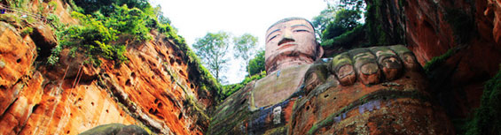
Le Shan
Le Shan is 30km east of Emei Shan. The city's relaxed atmosphere is just the right prescription for sore muscles after some tough hiking. The giant attraction of the city is the world's largest Buddha statue. It's 71m high and you'll feel infinitely small just compared with one of the Buddha's toenails. The statue is carved out from the rocks at the confluence of the Dadu, Minjiang and Qingyi Rivers. Legend has it the swift currents created by the clash of these rivers sunk innumerable ships and drowned their passengers. In AD 713 the monk Haitong began building the Buddha in the hope this would prevent further disasters. Construction finished 90 years later and the waste rocks from the carving succeeded in calming the waters.The sight of the Buddha is amazing, his head is 15m high, the nose is 6m long and the index fingers are 8m long. The best views of the Buddha are onboard a boat on the river or from the hills that flank its head. Admission to the Buddha is RMB 40 and opening hours are from 8am to 6pm.
The Dongfang Fodu Museum specializes in copying some of China's most famous Buddhist sites in large size –some even bigger than the original. Here is the world's largest reclining Buddha with a length of 173m. There is also a section of foreign Buddha from places including Japan, Nepal and India.
The Mahao Museum offers a glimpse of life during the Han dynasty. These cave tombs were dug high into the cliff over 2,000 years ago and are valuable for their insights into Han society, architecture, religion and politics. The tombs were furnished as typical Han dynasty dwellings for the spirit of the deceased to use in the afterlife and a treasure of relics have survived to this day.
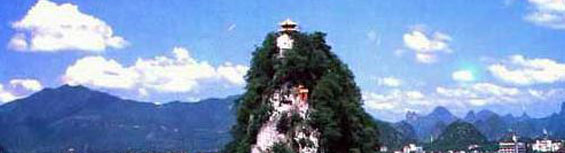
Solitary Beauty Peak
The Solitary Beauty Peak, located on the campus of the Guangxi Normal University in the center of the city, projects out from the ground like giant spike. The hill has a special light effect with its color changing from purple to golden as the sun rises and sets. Therefore, it is also called "Purple-golden Hill".The climb to the peak is steep, but the view from the top is worth the effort as you'll be able to take in the surrounding countryside along with the Li River. At the bottom of the peak is the Wang Cheng, which was a Ming dynasty palace where the regional imperial exams were held.
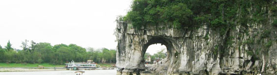
Elephant Trunk Hill
With a history of over 3.6 hundred million years and a height of about 200 meters, the Elephant Trunk Hill is a landmark of Guilin. It got this name because its appearance resembles an elephant sucking water from the river with its trunk.Between the trunk and the legs of the elephant lies the ‘Water-Moon Cave’ in the shape of a full moon. This cave and the surrounding hills have greatly added beauty and enchantment to the hill, especially at night. In the evening, when the day is fine, the cave with the water flowing below creates a fantastic scene of 'three moons': the water-moon cave, the moon in the sky and the moon reflected on the water. Another cave on the Elephant Trunk Hill serves as the eyes of the animal. The 'eye' is actually a 2-meter-high, 20-meter-long cave that goes through the hill from south to north. Thus it is named ‘Elephant Eyes Cave’. On top of the hill there is a pagoda named Puxian Pagoda, which can date back to the Ming Dynasty (1368 - 1644).
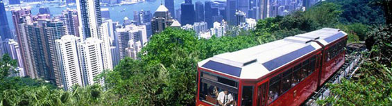
Victoria Peak
Much of the pleasure derived from a trip to Victoria Peak lies in the journey to its summit. The funicular railway or peak tram has steadily made its way up the mountain since 1888. Energetic travellers can scale the real peak that extends 140m (459ft) above the tram terminus. From the top marvellous vistas open out onto central Hong Kong and across to Kowloon. Victoria Peak used to serve as a hill station in colonial times and later became the location of exclusive summer homes. Today it is a popular tourist spot offering a cooler perspective from which to contemplate the pleasures of travel to the region. The Peak Tower on the summit houses numerous attractions, like a Ripley's Believe it or not 'Odditorium', shops and restaurants.
Purple Mountain (Zijin Shan)
The Purple Mountain, at the eastern edge of the city, is home to many of Nanjing's historical sights. A full day is needed explore all the sights. The newest addition to the field of sights is the Sun Yat-sen Mausoleum. After Sun Yat-sen, revered as the leading force in bringing down the Qing dynasty, died in 1925, his burial ground, fit for an emperor, was built. Pass through massive gates and climb 392 marble steps and you'll arrive in front of the mausoleum with white walls and a bright blue-tiled roof. A larger than life statue of Sun Yat-sen, appropriate for a man whose adventures included being kidnapped by Qing agents in London, greets you in the entrance to the main hall. Inscribed on the wall are his three principles for national salvation – nationalism, democracy and people's livelihood. In the round crypt is Sun Yat-sen's casket with a carved statue of him reclining. Behind the tomb is a small garden and a photographic exhibition from the early years of the Chinese republic. There's a great view over the lush green Purple Mountain from the top steps that lead up to the mausoleum– that is, when the weather permits it. The hills are often obscured by clouds and mist that lends the area an enchanting atmosphere.The Linggu Temple, a short walk from the mausoleum, rents bicycles, an ideal way to go from sight to sight around Purple Mountain. The centerpiece of the Linggu Temple is the 60m tall Linggu Pagoda. Moved here from the Tomb of Hongwu in 1381, it was destroyed during the Taiping Rebellion and rebuilt again in 1911 to commemorate those who died fighting to overthrow the Qing dynasty. The only remaining building on the premises is the Beamless Hall, 22m high and54mwide, and was built solely with bricks.
East of Sun Yat-sen's mausoleum is another mausoleum, the Tomb of Hongwu, the rebel turned emperor, Zhu Yuanzhang. He was born a peasant, did a stint as a monk, turned rebel to eventually become the first emperor of the Ming dynasty under the reign title Hongwu. The 13 other emperors of the Ming dynasty are buried near Beijing in the Ming Tombs –the capital was moved from Nanjing to Beijing after one of his sons usurped power from the chosen heir. The mausoleum was built between 1381 and 1383 and required over 100,000 laborers. Of most interest here is the "spirit way" leading up to the mausoleum. 12 pairs of stone animals flank the path; elephants, camels, horses and mythical beasts, a style also used at the better known Ming Tombs north of Beijing.
If time allows for it the Purple Mountain Observatory is worth a visit –if for nothing else butfor the view. It was built in 1929 and there's acable car ride to the top, 350m above sealevel.
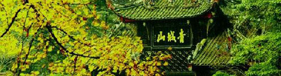
Qingcheng Shan (Mount Qingcheng)
In Guan County, about 60km from Chengdu, is Qingcheng Shan, a mountain that can be visited as a day trip. During the Han dynasty it became a center of Taoism when a Taoist master made the mountain his home. The Shangqing Hall sits over 1,600m above sea level and is the highest temple on the mountain. Halfway up the mountain is the Tianshi Cave where the old master used to give his lectures and is now home to the Taoist Association. Most of the buildings have histories going back to the Han dynasty or earlier, but the actual structures are mainly Qing dynasty or later. Many of the buildings, in accordance to Taoist beliefs, blend into the natural surroundings without disturbing nature's grace.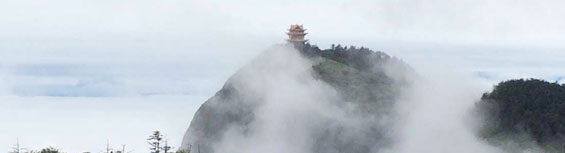
Emei Shan (Emei Mountain)
Emei Shan is the highest of China's four holy Buddhist Mountains, rising 3,099m above sea level about 170 km from Chengdu. Buddhists believe the mountain is home to Samantabhadra –patron of the Lotus Sutra and Bodhisattva of Pervading Goodness.The route to the summit crosses a lush and diverse landscape with enchanted rock formations, waterfalls and narrow gorges. Climbing upwards you'll encounter countless temples and pavilions. Thousands of pilgrims walk the way to the top –many of them elderly and sporting canes with their pockets filled with incense and ghostdom paper money to be burned.
The first temple erected on the mountain was built during the Han dynasty, and during the Ming and Qing dynasties, Emei Shan became one of China's most important centers for Buddhism. Many of its 100 temples fell into disrepair after the fall of the Qing dynasty, but since 1976, much has been done to restore past glory.
By far the most beautiful path to the top follows the southern route, which is also the longest. However, you'll be rewarded with marvelous landscapes and pass by colonies of monkeys. A word of warning, don't monkey around with the monkeys –they can be aggressive and they'll steal right out of your bag if you happen to open it in front of them. But if you act humble and show them your empty hands, they're also smart enough to go look for wealthier prey. Either that or buy a strong walking stick for self-defense.
At 550m is the Baoguo Temple with a 25-ton bronze bell dating from 1564. The Qingyin Pavilion offers some of the best views on the mountain. The Wannian Temple, built in the Jin dynasty houses a 7m high bronze figure of Samantabhadra sitting on a six-tusked white elephant weighing 62-tons. Between Hongchunping, at 1,120m, and the Xianfeng Temple you pass by the 99 Curves and the thousands of steps will start to make themselves felt in your muscles – but the splendid views here should reinvigorate even the exhausted. At the Leidongping Temple there is a cable car going to the top of the mountain. Continuing on foot from here takes another 2 hours. If the weather cooperates, the vista is divine at the 3077m high Golden Peak. This is the place to relax, meditate and enjoy the sunset. The sunrise is also one of China's legendary experiences, but enjoying this means hiking up at night to be at the peak by sunrise. On Golden Peak, the Golden Peak Temple is a very active place of worship – so transcendence might be lost among the hubbub of pilgrims. The highest point of Emei Shan is the Ten Thousand Buddha Summit at 3,099m, a monorail can take you there from Golden Peak.
Lao Shan (Mount Lao)
Lao Shan is one of the places where Taoism first originated. About 7km east of the Old Stone Man beach; the mountain is one of Taoism's most important pilgrimage destinations. In the past, Taoist priests living on the mountain were conferred with special privileges. The mountain saw the most development during the late-Song and early-Yuan dynasties and was home to over 100 temples, each searching for "the Way" in solitude. Ancient travelers thought immortals lived on this scenic mountain and many legends grew out of that belief.Lao Shan is now best known for its spring water, which isconsidered the best in China . It's also this spring water that made Qingdao famous for its beer. Not only is this water good for making people drunk, vegetables grown using this water are reputedly much tastier, something local fruit and vegetable peddlers will all point out.
There are many routes up the mountain and many hidden trails make it a joy to explore. Oddly, palm trees are abundant on Lao Shan despite being in the north, and note the varying vegetation at different elevations. At the end of Lao Shan Lu is the Palace of Great Purity , which is made of three pavilions. The main pavilionis Sanqing Pavilion, which houses a statue of Laozi, the founder of Taoism, and the mythical Jade Emperor. To the left of this pavilion is the Pavilion of the Three Emperors and to the right is the Pavilion of the Three Officials. These buildings were constructed during the Song dynasty to perform Taoist ceremonies. Beijiu Shui is just north of the Palace of Great Purity and is a wild area laced by rivers, streams and cascading waterfalls.
A cable car close to the Palace of Great Purity whisks visitors to Shangqing Gong at the peak of Lao Shan. Great views abound on Lao Shan, but make sure the strong ocean wind doesn't blow you off the mountain. South of the peak is the Dragon Pool Falls . Because of the high winds, the water is blown into spray that resembles a thundershower more than a curtain of water. Be careful in this area and stay on the high ground away from slippery surfaces. Visitors have been blown off the mountain and into the sea.
White Cloud Mountain (Baiyun Mountain)
White Cloud Mountain, located about 17 kilometers north of Guangzhou,has been one of the most famous spots of natural beauty in Guangzhou. People always describe the natural beauty of Guangzhou as being composed of white cloud and pearl sea, the white cloud referring to White Cloud Mountain.White Cloud Mountain is the ending range of Dayu Mountains in the south. It stands up over the flat area of the Pearl River Delta, called ‘the First Mountain of Southern Yue’ in history. Every time the sun shines after the rain, and through late spring, a wreath of airy clouds circles the mountains. This is how White Cloud Mountain has won its name. The mountain is of a rectangular shape, with a south-to-north length of 7 kilometers and an east-to-west length of 4 kilometers.
White Cloud Mountain consists of more than 30 peaks and covers an area of 28 square kilometers. The highest peak, Moxing Ridge stands in the center of the mountain, measuring 382 meters in height, also called ‘the First Peak under the Southern Sky’.
White Cloud Mountain has gorgeous scenery and abundant historical relics. ‘Wind Soughing in the Pines on Baiyun Mountain’, one of Guangzhou's eight scenic spots, refers to the mountain's pine waves caused by mountain wind.
White Cloud Mountain is a park with natural hills and waters, and an ideal sightseeing place and summer resort, with a development history of over 1,000 years. It has six areas, Bright Pearl Building Park, the San tailing Summit Park, the Bird Spring Valley Park (Mingchun Valley), the Santailing Park, the Luhu Park and the Fei'eling Park. Beside the existing scenes Moxing Ridge, Looking afar in the morning from Baiyun Mountain, Looking afar in the evening from Baiyun Mountain, the First Peak under the Southern Sky, Wind Soughing in the Pines and Songtao Villa, Mingzhu Tower, there have been added such scenic spots as Baiyun Cableway, Mingchun Valley - the largest birdcage in Asia, the Forest of Steles in Guangzhou, Nengren Temple, a golf course, Xinghai Garden, Yuntai Garden, the Sculpture Park and Baiyun Chute, etc.
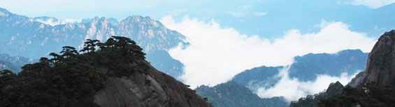
Huangshan Scenic Area (Yellow Mountain)
The Huangshan Scenic Area extends about 40 km from north to south and 30 km from east to west. As an important national scenic area, Huang Shan was listed as a UNESCO World Heritage Site in 1990 and as a result, the park is very well kept and amazingly enough in China, a no-smoking zone is strictly enforced.There are 72 peaks in total with Lotus Peak, Brightness Apex and the Celestial Capital Peak being thethree major ones, all towering above1,800m. Although 1,800m might not seemtoo awe-inspiring at first, the sheersteepness of the peaks and sense ofremoteness one gets when on Huang Shancoupled with frequent "weak knees" willmake you think otherwise.
As you initially ascend the mountain, you'll come across stunted pine trees contorted into curious shapes. What's more amazing is that these gnarled trees sprout from rocks that are just as oddly shaped. Eroded by wind and time, the rock formations, together with the stunted pines growing off them, have long been the muse of many painters and poets. The gnarled trees and craggy rocks are the subject of numerous traditional Chinese paintings and poems and have become a recognized symbol of Huang Shan. If you see such a painting, chances are Huang Shan was the inspiration for the work.
Ever wondered what it would be like to float on a sea of clouds? At Huang Shan you can –or at least get a close approximation. The sea of clouds in the Beihai Scenic Area is ever-changing and unpredictable; one moment you've got the picture-perfect shot of a twisted pine on the next peak and in the next, it has disappeared, engulfed in a swirl of mist and clouds. Resulting from the "now you see it, now you don't" effect, a certain surreal quality develops which can make you feel rather like an immortal.
There are hot springs at the foot of Huangshan, at Purple Cloud Peak. For those aching after a strenuous but un forgettable climb, this opportunity should be utilized to pamper those tired and aching legs and feet. First tapped over a thousand years ago, the clear waters remain at a constant 40°C year round and can be used for drinking and bathing, though not at the same time and from different pools. Special therapeutic baths and swimming pools have been built around the natural springs.
RECOMMENDED ROUTE
There are two main ways of getting to the top of Huang Shan, by foot or by cable car. A recommended route is to take the cable car up, ascending from the east side of the mountain to reach the Beihai, stay overnight at the summit and catch the magical sunrise, then descend by foot down the western side of the mountain. The western side is a lot steeper and isn't for the faint of heart. Although the scenery serves as a good distraction, don't be too distracted and lose your footing. If you do decide to climb the mountain, it's a 3-hour, 7.5km climb from the east and a hefty 15kmfrom the western approach, which will take at least twice as much time.
On the eastern side of Huang Shan close to the summit, is the Begin-to-Believe Peak. It's probably the most visited peak in Huang Shan due to its deep chasms and classic Huang Shan scenery. Along the way you might notice many locks clasped around the chain railings – these locks are meant to represent everlasting love. Couples romantically fasten their locks and throw the key off the peak, thereby cementing their relationship.
The Beihai Scenic Area is at the summit of Huang Shan. Paths are newly paved and well kept. This is the best place to view the sunrise above the eternal sea of clouds and pine tree-studded peaks.
Flying Rock in the western part of the summit area is a huge pear shaped rock 10m high perched precariously on top of the peak. Steps leading to the top of the peak have one dubious looking handrail allowing the brave to really experience being on top of the world if your eyes dare to stay open.
Along the central axis of the mountain is the Brightness Apex at 1,840m, this is the second highest peak on Huang Shan which it separates the physically challenging western side from the more gentle eastern side. This is a good place to contrast the two faces.
Jade Screen Pavilion is also known as the Jade Screen of Heaven. These fantastic sheer cliff faces feature unique rock formations with green pines. It looks like a giant Chinese landscape painting brought to life.
On the western side Lotus Peak is Huang Shan's highest peak. Surrounded by a group of lower peaks, Lotus Peak looks like a lotus flower in full bloom. The top of the peak offers panoramic views of Huang Shan though sore and wobbly legs are also inevitably part of the deal.
The Celestial Capital Peak faces Lotus Peak in the west. At 1,829m, it's the steepest peak, but a stone stairway is cut into the near vertical cliff face and those wanting to venture up, much of it on all fours, are aided by heavy chains hammered into the rock face. This stone stairway can easily be spotted from afar as a thin white line creeping up to the summit. It should be noted that during winter this peak may be closed. Even so, just looking at the peak is mind-blowing enough to give anyone vertigo.
After leaving the Huang Shan Scenic Area, in Tunxi there is an old trading street known as Tunxi Ancient Street. This 1.5km street has been a bustling center of trade since the Southern Song dynasty, taking its present day form during the Ming and Qing dynasties. Paved with bluestone, the street is lined on both sides with old shops in an unmistakable Huizhou architectural style characterized by fine woodcarvings on lattice windows and doors. The shops retain the essence of traditional stores of yesteryear, selling wares such as traditional medicines and local specialties including Shexian ink stones, Huang Shan Maofeng tea and Huizhou ink sticks.

Want More Information About China Holidays ?
Brochure Request
Call Us

If you would like us to help you create the perfect China Holiday then please call us on:
020 7487 2999 |
|
 |
4 Glentworth Street London - NW1 5PG |
英国旅游地接服务请点击
Enquiry Form
Popular China Tours |
Featured Articles |
Other Information |
|
|
||